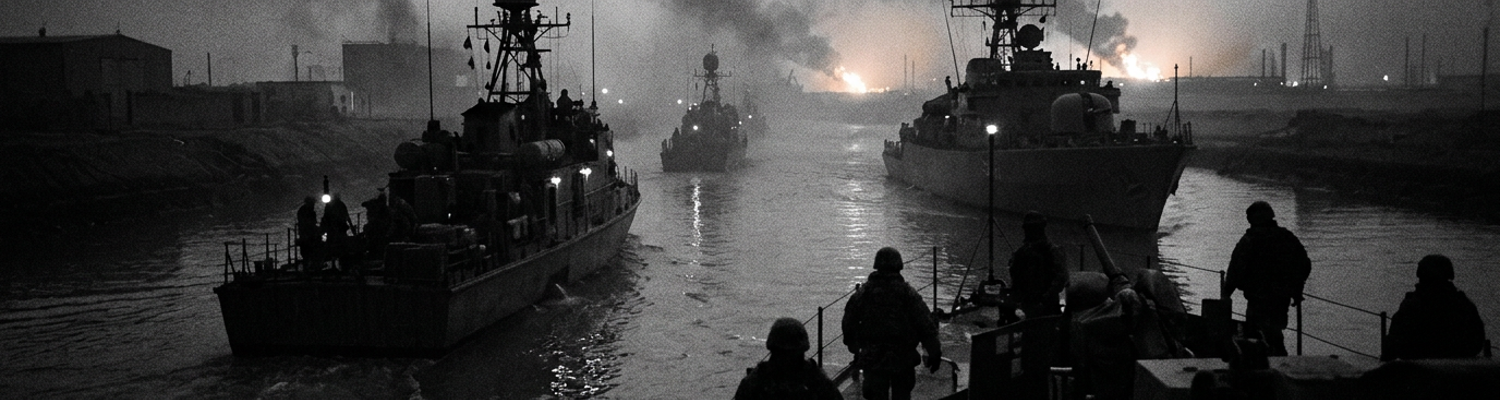

Coalition Task Group 55.1 Operational Mandate
Naval doctrine rejected the operation. Clearing a narrow estuary littered with sunken hulls to force thirty foot draft cargo ships into hostile Iraqi territory violated established maritime protocols. The geography of the Khawr Abd Allah waterway defied standard deep water shipping rules. Silt deposits from the Tigris Euphrates basin constantly shifted the bottom topography. Charted depths dropped to less than four meters in critical bends. Four knot currents and zero visibility water masked scuttled patrol boats, submerged shipping containers, and acoustic sea mines. When examining the historical record, Coalition maritime planners in early 2003 understood that civilian merchant freighters refused to approach without ironclad hull insurance and verified ten meter channel clearances. The operational plan required opening that waterway under combat conditions before ground forces had stabilized the surrounding riverbanks.
Headquarters demanded clear sea lanes anyway.
In the spring of 2003, Coalition Task Group 55.1 assumed tactical responsibility for clearing and escorting deep draft vessels into Iraq. Commanded by United States Coast Guard Captain Frank Sturm, the task group operated beneath the administrative authority of the Coalition Forces Maritime Component Commander based over two hundred miles south in Manama, Bahrain. A close review of operational logs indicates that this physical separation produced a severe operational disconnect between strategic planners and afloat commanders. Component headquarters issued execution orders based on twelve hour old satellite photographs and static intelligence slides. They ignored the localized physical chaos on the water. High frequency radio traffic suffered constant atmospheric disruption over the northern Persian Gulf. Patrol craft like the coastal patrol ship USS Firebolt and cutters like USCGC Boutwell waited hours for tactical clarification. Sturm held responsibility for coordinating mine countermeasure vessels, British Royal Navy hovercraft, explosive ordnance disposal divers, and armed security boarding teams across sixty miles of restricted brown water geography. Orders drafted in air conditioned Bahraini control rooms routinely directed deep draft traffic toward sectors where acoustic sweep gear had just snapped under current stress. Sometimes they directed ships where Iraqi small arms fire still raked the shoreline.
Tactical decisions occurred inside a communications void.
Archival evidence shows that the primary operational mission assigned to Task Group 55.1 was the reopening of the strategic southern deepwater port of Umm Qasr. This port facilitated essential humanitarian relief and logistical sustainment for invading Coalition ground forces. Iraq possessed no other deepwater access point capable of receiving the massive commercial cargo ships required to supply both a collapsing civilian population and an advancing army. The port complex at 30 degrees 02 minutes North 47 degrees 56 minutes East contained twenty one berths. Every slip was paralyzed by deliberate Iraqi sabotage. Iraqi forces had scuttled a crane barge, a tugboat, and several patrol vessels right at the pier faces. Coalition engineers and clearance divers had to hydrographically map every square meter of the channel floor using hand held sonar units because hull mounted systems choked on suspended mud. Task Group 55.1 had to establish secure transit windows through these narrow lanes. They aligned high tide windows with naval surface fire support schedules. On March 28, 2003, Australian divers cleared bottom moored LUGM 145 mines. The channel markers were reset. The Royal Fleet Auxiliary landing ship Sir Galahad pushed through the swept corridor carrying hundreds of tons of food, medical cargo, and bulk drinking water.
The transport docked with four feet of clearance under its keel.
Hydrographic Constraints of the Khawr Abd Allah Channel
Archival evidence shows that British hydrographic survey teams entering the lower Khawr Abd Allah found that active maritime charts had not received reliable hydrographic updates since 1990. Heavy sedimentation washed down from the Shatt al Arab basin continually altered the sea floor. This created a dynamic underwater mud bank structure across the entire approach to Umm Qasr. Dense fluid mud formed an acoustic barrier up to two meters thick along the dredged channel floor. Sonar pulses from Royal Navy survey motor boats like those deployed from HMS Roebuck reflected off this suspended particulate rather than the solid seabed. This blinded bathymetric sensors and disguised metallic mine shapes.
Extreme tidal ranges reaching four meters caused horizontal current velocities to spike between four and six knots through the narrowest cuts near the Warbah Island dogleg at 29 degrees 58 minutes North 48 degrees 08 minutes East. Cooling water intakes on 110 foot Island class Coast Guard cutters sucked in thick, abrasive silt. This tore through raw water pump impellers. Engineers had to disassemble clogged strainers every four hours.
Silt blinded every sensor in the water.
When examining the historical record, Coalition Force Maritime Component Commander staff officers in Manama calculated transit windows using standardized tidal tables. These tables failed to account for localized meteorological surges. Northwesterly shamal winds regularly depressed water levels across the northern gulf by more than half a meter. This invalidated the admiralty draft projections sent to Task Group 55.1. Deep draft cargo vessels requiring nine to ten meters of clearance had to squeeze into a dredged channel barely one hundred meters wide. Vessel masters discovered that under keel clearance frequently dropped below thirty six inches during peak ebbs. Steering control deteriorated as hydrodynamic interaction with the shallow trench banks pulled ship sterns toward the shallows. This physical suction effect repeatedly threatened to run heavy supply hulls aground directly in the transit path.
The ships could not deviate from the centerline by more than fifty feet.
A close review of operational logs indicates that this extreme hydrographic confinement turned every supply run into a stationary target for Iraqi forces positioned along the al Faw peninsula. Deep draft freighters could neither turn around nor alter their headings without immediately grounding on the hard mudflats. Iraqi defensive units knew the exact coordinates through which every high value target had to travel. Merchant captains had to maintain a rigid, predictable speed of six knots behind Royal Navy Hunt class minehunters like HMS Chiddingfold and HMS Ledbury. Moored LUGM 145 contact mines and bottom laid influence mines drifted into the primary shipping cut. Violent cross channel rip tides swept them into clusters. Iraqi small boat teams operating fiberglass dhows out of hidden inlets near Ras al Bisha concealed rocket propelled grenade teams and sea skimming mines just two miles off the port beam of Coalition transports. Afloat tactical commanders repeatedly alerted Bahrain that any minor mechanical failure or aborted transit would trap the entire column in an uncleared channel. Component headquarters continued scheduling multi ship convoys during the dead of night based on theoretical tide curves.
On March 26, the bulk carrier Manar scraped its keel against an uncharted silt bar at 29 degrees 59 minutes North 48 degrees 15 minutes East.
The vessel held fast for five hours while armed Iraqi skiffs probed the outer security perimeter.
Environmental Degradation of Shipboard Sensor Suites
Archival evidence shows that thermal imaging systems deployed across the northern Khawr Abd Allah failed during the opening forty eight hours of combat operations.
Plumes of heavy crude smoke drifted southeast from seven ignited wellheads in the southern Rumaila oilfields. These combined with burning gas separation manifolds along the al Faw peninsula to blanket the estuary. Suspended carbon soot particles absorbed and scattered light within the 8 to 12 micrometer infrared spectrum. This degraded shipboard forward looking infrared sensors mounted on Cyclone class patrol ships and Coast Guard cutters. Estuary water temperatures hovered near eighteen degrees Celsius. The dense hydrocarbon pall trapped daytime surface heat. This produced a severe atmospheric thermal inversion layer extending eighty feet above the water. This inversion equalized ambient atmospheric temperatures with surface target profiles. It eliminated the thermal contrast required for microbolometers to distinguish metal and fiberglass objects.
Shipboard forward looking infrared consoles suffered complete target masking and thermal washout.
Watchstanders in the combat information center of the patrol craft USS Chinook alternated between black hot and white hot polarities. They only found the river surface and the air register as an identical field of flat grey phosphor. Drifting LUGM 145 contact mines, low profile fiberglass dhows, and floating sabotage charges disappeared entirely from infrared view screens.
The forward looking infrared suites went completely blind.
A close review of operational logs indicates that shipboard navigation and surface search radars suffered an equally severe operational breakdown inside the channel. Standard AN SPS 64 and AN SPS 73 navigation radar suites aboard Task Group 55.1 escorts were calibrated for open water sweeps rather than hydrographically constrained river mouths. Between the mud flats of Bubiyan Island and the al Faw coastline, emitted radio frequency pulses bounced off shallow water boundaries. This produced violent multipath interference. High frequency X band radar beams struck dense, waterlogged Phragmites reed beds and saturated salt marshes lining the eastern shore. This generated massive backscatter reflections that displayed on bridge indicators as non existent land features where only ankle deep shallows lay. At midnight, thick river fog rolled down from the Shatt al Arab marshlands. This suspended microscopic water droplets that absorbed and refracted the nine gigahertz radar signals. False contacts populated the displays in dense geometric patterns. This wiped out raw radar returns across the central three mile sweeping arc and prevented operators from tracking fast moving surface threats.
When examining the historical record, component commanders in Bahrain misjudged this equipment degradation. They issued convoy movement orders under the belief that Task Group 55.1 held continuous automated tracking over the channel. Operations centers in Manama reviewed clear, high resolution satellite passes and assumed afloat vessels possessed identical visibility. They were completely detached from the localized atmospheric soup blinding shipboard equipment on the water. At 0230 hours on March 23 near coordinate 29 degrees 56 minutes North 48 degrees 18 minutes East, the combat direction center aboard USS Firebolt turned off automated track while scan routines. Marshland backscatter had triggered dozens of false target alarms every minute. Technicians attempted to manually gate radar sensitivity. Clearing the clutter erased legitimate returns from low freeboard skiffs. Bridge personnel discarded their night vision goggles after soot deposits coated the optical glass. This forced boatswains mates onto the bridge wings to sweep handheld halogen searchlights across the water to spot floating obstructions sixty yards off the bow.
Human eyes on the exposed bridge wing became the only functional sensor left.
The Tactical Dilemma of Unlit Dhow Traffic
Archival evidence shows that indigenous civilian dhows regularly entered the Khawr Abd Allah under total blackout conditions between dusk and sunrise. Hundreds of wooden hulled sambuks and motorized jalibuts operated across the border waters between Kuwait, Iran, and the al Faw peninsula. They transported smuggled fuel, grain, and livestock. These traditional craft displaced between twenty and eighty tons. They were constructed with heavy teak planking that absorbed pulse compression radar frequencies instead of bouncing them back to shipboard receivers. Local operators ran through the narrow shipping channels without installing or activating standard red and green navigation sidelights, white masthead range lamps, or stern markers. None carried automated identification systems or commercial VHF marine transponders. They had operated for generations outside international maritime conventions. In the shallow cuts north of Ras al Qayd, civilian crews routinely ran dark to evade Iraqi naval patrols and regional customs enforcement. To watchstanders aboard Task Group 55.1 vessels, these unlit wooden hulls were visually indistinguishable from Iraqi fast attack skiffs armed with rocket propelled grenades or floating contact mines.
Radar screens displayed empty black water while fifty ton hulls slipped past three hundred yards away.
When examining the historical record, component commanders in Bahrain failed to grasp the proximity of this civilian traffic to combat operations. Maritime operations center staff officers in Manama monitored blue force tracking displays and commercial shipping lanes on digital map overlays. They operated under the assumption that non combatant craft would observe Coalition transit bans. Operational directives drafted hundreds of miles south ordered escort elements to enforce a four thousand yard exclusion zone around deep draft logistics freighters. In the constricted geography of the lower estuary, the cleared channel narrowed to three hundred yards between mudflats. That command directive was geometrically impossible to execute. Local boatmen knew nothing of naval exclusion zones declared by foreign headquarters. Dhow masters piloted their vessels solely by coastal silhouettes and depth poles. They steered straight down the deep draft centerline where Coalition minesweepers worked. Delayed communications from Bahrain left afloat commanders without updated intelligence on local fishing patterns. This forced patrol craft to assess the hostile intent of unverified contacts within sixty seconds of visual acquisition.
A small wooden boat could deliver a suicide bomb or fifty pounds of plastic explosives before an escort could verify its registration.
A close review of operational logs indicates that escort crews aboard 110 foot Coast Guard cutters and Cyclone class patrol craft were forced into aggressive escalation of force procedures to turn away unverified vessels closing on intercept headings. Watch teams on vessels like USCGC Adak and USS Firebolt relied on hand held Mk 127 parachute flares fired from bridge wings to pierce the black water. When fired, these magnesium charges erupted at six hundred feet. They generated one hundred thousand candlepower of harsh white light that drift burned downward for forty seconds. The sudden glare overloaded AN PVS 7 night vision optics and blinded the shipboard watchstanders who fired them. This plunged bridge wings into temporary disorientation. If a dhow held its heading toward the convoy column at ten knots, gunners stationed at forward mountings engaged with direct fire. Mk 38 25 millimeter Bushmaster chain guns and M2HB .50 caliber heavy machine guns fired five round warning salvos fifty yards across the bow of the approaching vessel. Tracer rounds skip ricocheted over the chop. They threw up violent water plumes to force non compliant helmsmen to wrench their rudders hard into the mudflats.
At 0140 hours on March 27 near coordinate 29 degrees 53 minutes North 48 degrees 26 minutes East, USCGC Aquidneck expended three illumination canisters and fifty rounds of .50 caliber ball ammunition.
They diverted an unlit sixty foot cargo dhow steering directly into the side of an ammunition transport.
Rear Command Isolation and Tactical Disconnect
When examining the historical record, Coalition Forces Maritime Component Commander staff officers stationed at Naval Support Activity Bahrain in Manama tracked the Khawr Abd Allah through a sanitized layer of administrative abstraction. Rear commanders evaluated channel clearance using satellite photographs that were twelve to eighteen hours old by the time staff intelligence officers pasted them into morning PowerPoint slides. The Global Command and Control System Maritime terminal displays presented clean digital icons across static vector maps. They showed neat blue ship tracks through the narrow waterway. In the air conditioned command spaces two hundred and fifty miles south of the fighting, staff planners assumed these computer generated plots reflected actual ship positions and hydrographic safety. That operational picture omitted the four knot tidal currents tearing loose bottom silt, the thick oil smoke blanketing the water from burning wellheads, and the unverified radar contacts crowding the margins of the swept channel. Captain Frank Sturm and the afloat commanders of Task Group 55.1 submitted urgent after action summaries detailing near miss groundings and recurring acoustic mine alerts. Rear staff officers regularly condensed these lengthy tactical field reports into brief green coded readiness blocks for daily executive briefings.
Static map graphics replaced the physical hazards of the estuary.
Archival evidence shows that this processing delay severed rear planners from the tempo of the combat zone. Tactical situation reports sent from afloat units over low bandwidth SIPRNET and commercial INMARSAT links backed up in digital queues for hours. This created a perpetual operational lag. Staff officers in Bahrain evaluated convoy routes using twelve hour old clearance data. They assigned civilian cargo hulls to transit sectors where Royal Navy minehunters had not yet swept the seabed or verified water depths. When tactical commanders requested schedule revisions to account for local tidal ebbs, planning teams in Manama denied the requests. Channel timelines had already been locked into the theater logistics matrix. Rear staff evaluated estuary security through static checklists rather than local environmental observations. They treated the Khawr Abd Allah as an open shipping lane rather than an active, uncontained combat sector.
Headquarters prioritized logistics schedules over hydrographic confirmation.
A close review of operational logs indicates that higher headquarters compounded this isolation by imposing rigid rules of engagement that collapsed under local brown water conditions. Component commanders in Manama mandated standard open ocean standoff procedures. They directed Task Group 55.1 escorts to maintain a thousand yard exclusion zone around logistics hulls and establish strict positive identification of hostile intent before employing defensive fire. In the dense river fog and crude oil smoke near the Warbah Island dogleg at 29 degrees 58 minutes North 48 degrees 08 minutes East, line of sight routinely dropped below seventy five yards. At that distance, an unlit wooden dhow or high speed fiberglass skiff traveling at twenty knots closed the gap to a Coalition patrol hull in under seven seconds. Non engagement directives explicitly prohibited pre emptive warning shots or interdiction fire against approaching craft unless watchstanders verified visible small arms, rocket propelled grenade launchers, or naval mines on board. Escort crews aboard Cyclone class patrol craft like USS Chinook and 110 foot cutters like USCGC Wrangell were systematically barred from taking defensive action against vessels that ignored visual signals, searchlight sweeps, and bridge to bridge radio challenges.
Shipboard gunners had seconds to determine if a dark hull held fishermen or explosives.
Operational records from March 25, 2003, record that afloat commanders requested immediate authorization to fire disabling warning rounds into the engine blocks of non compliant skiffs closing within four hundred yards of ammunition transports. Staff lawyers and operations officers in Bahrain denied the authorization. They cited potential diplomatic fallout in Kuwaiti border waters and the risk of striking non combatant smugglers. Patrol craft watchstanders were forced to rely on handheld halogen spotlights and ship horns to alter the headings of fast closing craft in zero visibility conditions. They waited until unverified vessels were close enough to throw grappling hooks across their gunwales before establishing clear hostile intent under theater directives.
The directives favored political caution over vessel survival.
Divergent Combat Conditions Along the Waterway Axis
Archival evidence shows that tactical crews assigned to Task Group 55.1 operated under continuous threat of surprise ambushes while rear echelons operated under the assumption of a stabilized maritime boundary. In the early morning hours of late March 2003, Coalition Forces Maritime Component Commander staff officers in Manama logged the northern Persian Gulf border as an administratively pacified transit sector following the initial amphibious insertion of Royal Marines along the al Faw peninsula. Blue force tracking monitors at Naval Support Activity Bahrain displayed static operational lanes along the Iran Iraq frontier. They marked the waterway as secure for standard shipping. At water level, Iraqi paramilitary forces, including Fedayeen fighters and coastal defense remnants, occupied mud walled observation posts and drainage ditches lining the eastern bank of the al Faw peninsula near Ras al Bisha at 29 degrees 55 minutes North 48 degrees 24 minutes East. Concealed inside dense salt marshes and abandoned oil monitoring platforms, Iraqi units launched hit and run assaults. They used PKM 7.62 millimeter machine guns and shoulder fired RPG 7 anti tank rockets against passing patrol craft. Shallow draft requirements forced vessels like USCGC Adak and USS Chinook to maneuver within one hundred and fifty yards of uninspected mudflats to stay inside dredged channels. This exposed open bridge wings to point blank direct fire from unseen positions ashore.
Operations centers in Bahrain marked the al Faw shoreline as secured while frontline gunners ducked machine gun fire from unmapped tidal creeks.
When examining the historical record, this tactical exposure worsened whenever escort craft throttled back to investigate suspicious shoreline movements. Sudden evasive turns pushed vessel hulls outside the narrow cleared track. Raw water engine intakes sucked up thick silt that jammed Detroit Diesel strainers and caused twin engines to overheat within minutes. Damage control teams aboard 110 foot Island class patrol cutters had to strip and back flush salt water intake valves while small arms fire peppered the steel superstructure. Higher headquarters dismissed field requests for close air support or armed helicopter overflights. They replied that ground elements had already cleared the western bank and that persistent ambush threats were improbable. Tactical commanders on the water documented at least five separate shoreline skirmishes along the Warbah Island corridor where patrol boats engaged small armed teams hiding behind scuttled fishing skiffs. Morning intelligence briefings in Bahrain continued listing the transit cut as cleared of enemy resistance.
A single rocket propelled grenade could breach the unarmored hull of a minesweeper in seconds.
A close review of operational logs indicates that the divide between operational assumptions in the headquarters bubble and frontline friction delayed the routine clearance of logistical shipping into Umm Qasr. Maritime planners in Manama operated on a rigid timetable. They scheduled deep draft humanitarian freighters and commercial cargo hulls to begin daily docking cycles at the port by March 24. Frontline clearance units discovered that Iraqi forces had turned the harbor into an impassable field of marine wreckage and bottom ordnance. Royal Navy Fleet Diving Unit 3 and Australian Clearance Diving Team 3 spent days hand sweeping the berths at 30 degrees 01 minute North 47 degrees 57 minutes East. They discovered that the Iraqi military had scuttled the tug Al Fao, two patrol craft, and an eight hundred ton crane barge directly across the main commercial wharves. Bottom laid LUGM 145 contact mines and tethered acoustic devices rested beneath two feet of shifting river mud. These triggered continuous false contacts on AN SQQ 32 variable depth sonars. This forced minehunters like HMS Brocklesby and USS Ardent to halt sweep operations until divers physically probed the silt by hand.
Staff officers in Manama viewed the delay as an administrative failing. They issued daily dispatch cables urging afloat commanders to bypass non metallic sonar returns to meet high profile political delivery deadlines. Captain Frank Sturm and British afloat mine countermeasures commanders refused to risk civilian merchant vessels or landing ships in uncleared waters. They knew commercial insurers had rescinded coverage for any ship entering an uncertified channel. High tidal currents snapped the umbilical cables of AN SLQ 48 remote mine neutralization vehicles. Clearance teams had to rely on basic hand held grappling hooks to sweep berths one through eight. The landing ship RFA Sir Galahad was held waiting at anchor for four days beyond its scheduled arrival time. Divers cleared an unmapped acoustic sea mine located fifty yards from the southern pier face (NARA Record Group 313).